
Planning the Route
The days continue counting down, axes are in full swing for Draken’s hull reinforcements, and our departure date is getting closer. Focus is everywhere. There is much remaining to do and it feels like it all must be done at once.
Sometimes it’s hard for me to focus when I know I should be fitting a deck beam, shaping a block, or thinking about the rigging that needs to be tarred. There are a dozen hearts the size of Thor’s head that need to be stropped to the hull with laid hempen grommets. The finished process of these strops alone could take weeks of tarry, wrist numbing work.
Instead, am sitting here in our second floor office with a northern view of the cloudy Norwegian skies over the quaint island of Vibrandsøy. I find myself consuming bad but strong coffee, frequently zooming in and zooming out, dragging east and dragging south, on digital charts checking bridges and depths of the canal systems that connect the great lakes to the Big Apple.
An expedition like this will take time. It is several thousand nautical miles across the North Atlantic, past Iceland, and through the crystal blue and white iceberg fields between Greenland and Newfoundland, which happens to be much farther north than where Titanic met her unfortunate fate. It is then hundreds of nautical miles southwest through Canada and her Saint Lawrence seaway before we can maybe have a little rest in Quebec.
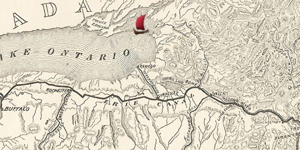
With will, we continue a few hundred nautical miles further by Montreal and Toronto, exploring the Great Lakes and visiting several cities before sailing our way to the river and canal systems that connect the blue waters of the Atlantic oceans with the Great Lakes. Those canal systems connect a series of rivers and lakes between New York City and Lake Ontario, saving thousands of miles for ships wanting to travel southward from the Great Lakes.
The New York Canal system poses some difficulty for us. There are locks that we must squeeze into that will help us climb over the hills that separate these mighty lakes and rivers, but especially, there are bridges. These bridges are fixed. They do not move, and there are a lot of them. This would be just fine for us if there is say ninety feet of clearance above the water level for our mast. There isn’t. Not even close. Fine, we are a viking ship, we will rig down our mast and row if we must. (Yes, yes.. we have engines. Just let me over-dramatize this
Upon closer inspection of THIS-TOO-MANY bridges across forty six charts, I have decided it might be a pretty good idea to remeasure the ship again. The twelve lowest bridges measure 20 feet from the waters surface. With Draken’s stems measuring nineteen feet and two inches, that gives us eight inches of wiggle room.
Eight.
If we set a 20 ounce bottle of coke* on top of our stem, these bridges would knock it off into the water.
Cross your fingers, or hold your thumbs as they say in Scandinavia, and come see for yourself if we make it under these bridges!
Back to the axe,
Woody – Sailor/Hemp rig specialist
*The 20oz bottle of Coke was only used as a visual reference. I do not support the consumption of Coke especially, or other products that are packaged in plastic bottles.
Picture: “A map of the country traversed by the Erie Canal” — from “Water-ways from the Ocean to the lakes” / by Thomas Curtis Clarke; in: Scribners Magazine, Vol. XIX, no. 15, 1896, p. 104.